Deforestation
Agribusiness is the main responsible for the loss of native vegetation in Brazil, says study
According to MapBiomas, pastureland has expanded by 79% and agriculture by 228% in the last 39 years
By Leonardo Fernandes
From Brasil de Fato
MapBiomas’ Collection 9 of annual land cover and land use maps, released on Wednesday (21), revealed an accelerated loss of native vegetation area between 1985 and 2023, reaching 33% of the entire national territory last year. The report takes into account areas of native vegetation, in addition to forests and woodlands, water surfaces and non-vegetated natural areas, such as beaches and dunes.
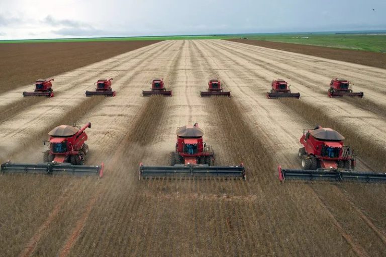
The process of anthropization of areas of native vegetation is mainly due to the expansion of agriculture, according to the institute. Brazil currently has 64% of its territory covered by native vegetation. In 1985 it was 76%. In the same period, pastureland expanded by 79%, 72.5 million hectares more than 39 years ago. Agriculture, on the other hand, grew by 228%, an increase of 42.4 million hectares of cultivation, mainly of grains for export.
The report notes that more than half of the native vegetation lost in recent decades has been concentrated in the Amazon, amounting to 5 million hectares lost in the last four decades. “We’ve seen a very predatory growth in farming in the Amazon region, with a deforestation process that basically involved invading a public land area, removing the hardwood trees that had some commercial value, then felling the remaining vegetation with the “correntão” technique (which consist on two tractors positioned in opposite sides dragging a strong chain through a piece of forest, taking down at once all the vegetation in that area), waiting for it to dry out and setting it on fire. A pasture with very low productivity would be cultivated in an attempt to regularize the land or take possession of it. Afterwards, if this process succeeded, the new landowner would sell the area on to someone else for soybean cultivation and then go on to deforest a new area. This model was used for a long time,” says Marcos Rosa, technical coordinator of MapBiomas.
However, the researcher warns that the occupation of land by agriculture is losing strength in the Amazon and migrating to other regions of the country. “In the Amazon, we’re seeing a huge drop in deforestation, especially illegal deforestation. What we are seeing is this expansion now happening in the Cerrado region, mainly in Matopiba, for large enterprises, primarily soy monoculture,” he says.
The Matopiba region is mostly made up of the Cerrado biome, comprising the states of Maranhão, Tocantins, Piauí and Bahia, and is considered Brazil’s last agricultural frontier. In its latest alert on the region, MabBiomas accounts for more than 2.7 million hectares deforested in Matopiba between 2019 and 2023, which contributed for the Cerrado to be the biome with the highest number of deforestation alerts in this period.
According to the report, agriculture went from 28% to 47% in the Cerrado, while in the Pampa biome region it went from 28% to 45%. In the Amazon, it went from 3% to 16% and from 5% to 17% in the Pantanal biome region. The Caatinga biome region saw an increase of 10% in agriculture, from 28% to 38%, and the Atlantic Forest was the biome where agriculture varied the least, from 63% to 65%.
The data presented by MapBiomas shows that in 1985, 48% of municipalities had a presence of agriculture, while in 2023, this predominance reached 60% of municipalities. The states that saw the biggest growth in the areas used for pasture were Rondônia, which went from 6% to 38%; Maranhão, which went from 5% to 29%; Mato Grosso, from 6% to 24% and Tocantins, from 7% to 30%.
Agribusiness invades the Pantanal
In the Pantanal, the sharpest reduction has been in water surface, which has gone from 21% in 1985 to 4% in 2023, a clear effect of climate change. Experts warn that the prolonged droughts have led to the occupation of previously floodable lowland areas by agribusiness, with monoculture plantations.
“In the upper part of the plateau, there is a lot of soybean expansion, and in many cases it even occupies Permanent Preservation Area (APP), which is the area that should be protecting the rivers, and have been destroyed. But now there is an initiative to recover some of these areas. And that’s the big problem: when you prepare the soil for soybeans, the rain takes sediment from the soil into the rivers and that sediment reaches the plains,” explains Marcos Rosa.
Another effect of the drought in the Pantanal pointed out by experts is the change in the pattern of Pantanal livestock farming.
“What we can see is that the flooded area is becoming smaller, and the duration of the flood is shorter. And this drought has led to the expansion of farming, especially in the interior of the Pantanal. And there is a change in the pattern of this type of livestock farming. Traditional wetland cattle farming in the Pantanal, carried out on native grasslands, (we always classify it as such), is important to be maintained, it’s a traditional use of the land. What we’re seeing today is a change with the complete removal of the native vegetation and the planting of exotic vegetation [pasture],” says the MapBiomas researcher.
What to do?
For those who produce food and advocate for the adoption of sustainable soil management methods, there is no way to dissociate the environmental debate from access to land and the country’s agricultural development model. This is what Maíra Santiago, from the Landless Rural Workers’ Movement (MST), says.
“The movement has a strategy for building a new type of agrarian reform, which we call popular agrarian reform. And within this popular agrarian reform, what is vital to us is the fact that it is possible to reconcile the production of healthy food with caring for nature,” she says.
Maíra says that aside from its commitment to the struggle for land and the production of agro-ecological food, the MST has developed national reforestation plan, which aims to plant 100 million trees by 2030, in all regions of the country. The MST leader is calling on the government to take stronger measures to tackle climate change, advance the agro-ecological transition and, consequently, end hunger.
“There is a difference between what is central to us, which is reducing or slowing down climate change, and what the government is proposing. The government still invests a lot in actions linked to what capitalism, green capital and the carbon market are pointing to as solutions. And for us, it isn’t green hydrogen, nor the carbon market that will provide concrete solutions to climate change, but rather agrarian reform, the democratization of land and agroecology as central elements,” she says.
As for the MapBiomas researcher, he hopes that the data provided by the study will help create policies to protect biomes and tackle the climate emergency.
“MapBiomas’ mission is to produce this data to be used to mitigate climate change. So, we produce the scientific data, make it public, and we spend half of our time producing the data, while the other half is spent making sure this data is used. Our goal is to show the data and ensure that it is incorporated into short-, medium- and long-term planning policies, as well as being used to support such discussions,” concludes Rosa.
MapBiomas data is available for free consultation on a digital platform.
Editing: Nathallia Fonseca/ Translation: Natalie Illanes Nogueira